Showing 358 items matching crown lands
-
 Federation University Historical Collection
Document, Crown Lands Alienated , 1861
... Crown Lands Alienated , 1861...crown lands... to alienated Crown Lands. ... Document Crown Lands Alienated , 1861 Blue Foolscap printed ...Blue Foolscap printed Government document relating to alienated Crown Lands. crown lands -
Federation University Historical Collection
Document, Crown Lands in Villiers and Westward Counties, 1856-7
... Crown Lands in Villiers and Westward Counties, 1856-7...crown lands...Blue foolscap printed Government document lon Crown lands... Document Crown Lands in Villiers and Westward Counties, 1856-7 Blue ...Blue foolscap printed Government document lon Crown lands in Villiers and Westward Counties. It inlcudes the return shoiung number of acres of land sold and the amount received for same. land, land sales, villiers, heytesbury, hampden, normanby, dundas, follett, crown lands -
 Peterborough History Group
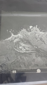
Photograph - Aerial Photograph Peterborough, Department of Crown Lands & Survey, Jan 1971
... Department of Crown Lands...Stamped Dept of Crown Lands & Survey...Department of Crown Lands & Survey... photograph x 4 - (2 photos in duplicate) Stamped Dept of Crown Lands ...Aerial photograph showing the past layout of the townSignificant in that it shows the town as it was in 1971.Square 9" x 9" aerial photograph x 4 - (2 photos in duplicate)Stamped Dept of Crown Lands & Surveypeterborough 3270, curdies estuary, bay of islands, crown land photograph, aerial photograph, department of crown lands -
 Bayside Gallery - Bayside City Council Art & Heritage Collection
Photograph, Department of Crown Lands and Survey, Victoria, Melbourne Project: Brighton, 1976
... Department of Crown Lands and Survey...The Department of Crown Lands and Survey (1857-1983...Department of Crown Lands and Survey, Victoria... Brighton Department of Crown Lands and Survey Aerial photograph ...The Department of Crown Lands and Survey (1857-1983) was responsible for the administration of survey and mapping and the sale, occupation and management of crown land throughout its existence. This aerial photograph shows parts of Brighton and was taken on 1 December 1976brighton, department of crown lands and survey, aerial photograph, bayside, port phillip bay, map, cartographic material, melbourne project 1976, brighton yacht club, middle brighton baths, north road, st kilda street, new street -
 Bayside Gallery - Bayside City Council Art & Heritage Collection
Photograph, Department of Crown Lands and Survey, Victoria, Melbourne Project: Brighton and Elwood, 1976
... Department of Crown Lands and Survey...The Department of Crown Lands and Survey (1857-1983...Department of Crown Lands and Survey, Victoria... of Crown Lands and Survey (1857-1983) was responsible ...The Department of Crown Lands and Survey (1857-1983) was responsible for the administration of survey and mapping and the sale, occupation and management of crown land throughout its existence. This aerial photograph shows parts of Brighton and Elwood and was taken on 1 December 1976brighton, elwood, department of crown lands and survey, aerial photograph, elsternwick park, point ormond, north road, ormond esplanade, st kilda street, glen huntly road, bayside, port phillip bay, map, cartographic material, melbourne project 1976 -
 Bayside Gallery - Bayside City Council Art & Heritage Collection
Photograph, Department of Crown Lands and Survey, Victoria, Melbourne Project: Brighton and Hampton, 1976
... Department of Crown Lands and Survey...The Department of Crown Lands and Survey (1857-1983...Department of Crown Lands and Survey, Victoria... margin at the bottom. The Department of Crown Lands and Survey ...The Department of Crown Lands and Survey (1857-1983) was responsible for the administration of survey and mapping and the sale, occupation and management of crown land throughout its existence. This aerial photograph shows parts of Brighton and Hampton and was taken on 1 December 1976. brighton, department of crown lands and survey, aerial photograph, bayside, port phillip bay, map, cartographic material, melbourne project 1976, brighton yacht club, middle brighton baths, hampton, green point, brighton beach, south road, the esplanade, hampton street -
 Bayside Gallery - Bayside City Council Art & Heritage Collection
Photograph, Department of Crown Lands and Survey, Victoria, Brighton, Brighton East and Bentleigh, c. 1965-71
... Department of Crown Lands and Survey...The Department of Crown Lands and Survey (1857-1983...Department of Crown Lands and Survey, Victoria... Road at the bottom. The Department of Crown Lands and Survey ...The Department of Crown Lands and Survey (1857-1983) was responsible for the administration of survey and mapping and the sale, occupation and management of crown land throughout its existence. This aerial photograph shows parts of Brighton and Brighton East and was taken circa 1965-71.brighton, department of crown lands and survey, aerial photograph, bayside, port phillip bay, map, cartographic material, brighton east, dendy park, dendy street, centre road, nepean highway, south road, brighton golf course, golf -
 Bayside Gallery - Bayside City Council Art & Heritage Collection
Photograph, Department of Crown Lands and Survey, Victoria, Brighton, Elwood and Elsternwick, c. 1965-71
... Department of Crown Lands and Survey...The Department of Crown Lands and Survey (1857-1983...Department of Crown Lands and Survey, Victoria... at the bottom. The Department of Crown Lands and Survey (1857-1983 ...The Department of Crown Lands and Survey (1857-1983) was responsible for the administration of survey and mapping and the sale, occupation and management of crown land throughout its existence. This aerial photograph shows parts of Brighton, Elwood and Elsternwick and was taken circa 1965-71.brighton, department of crown lands and survey, aerial photograph, bayside, port phillip bay, map, cartographic material, elwood, elsternwick, elsternwick park, elwood tram depot, elwood pier, new street, glen huntly road, st kilda street, nepean highway -
 Bayside Gallery - Bayside City Council Art & Heritage Collection
Photograph, Department of Crown Lands and Survey, Victoria, Melbourne Project: Brighton, Hampton, Sandringham, 1976
... Department of Crown Lands and Survey...The Department of Crown Lands and Survey (1857-1983...Department of Crown Lands and Survey, Victoria... at the bottom. The Department of Crown Lands and Survey (1857-1983 ...The Department of Crown Lands and Survey (1857-1983) was responsible for the administration of survey and mapping and the sale, occupation and management of crown land throughout its existence. This aerial photograph shows parts of Brighton, Hampton and Sandringham and was taken on 1 December 1976brighton, department of crown lands and survey, aerial photograph, bayside, port phillip bay, map, cartographic material, hampton, sandringham, green point, sandringham yacht club, south road, beach road, hampton street, melbourne project 1976 -
 Bayside Gallery - Bayside City Council Art & Heritage Collection
Photograph, Department of Crown Lands and Survey, Victoria, Brighton, Brighton East and Bentleigh, c. 1965-71
... Department of Crown Lands and Survey...The Department of Crown Lands and Survey (1857-1983...Department of Crown Lands and Survey, Victoria... Road at the bottom. The Department of Crown Lands and Survey ...The Department of Crown Lands and Survey (1857-1983) was responsible for the administration of survey and mapping and the sale, occupation and management of crown land throughout its existence. This aerial photograph shows parts of Brighton, Brighton East and Bentleigh and was taken circa 1965-71.brighton, department of crown lands and survey, aerial photograph, bayside, port phillip bay, map, cartographic material, bentleigh, brighton east, dendy park, dendy street, centre road, nepean highway, south road, football -
Port Melbourne Historical & Preservation Society
Document - Notice, Auction, Crown Lands, 1892
... Notice, Auction, Crown Lands...Auction notice of Crown lands, 1892... Street) Port Melbourne melbourne Notice, Auction, Crown Lands ...Auction notice of Crown lands, 1892town planning, land sales -
 Federation University Historical Collection
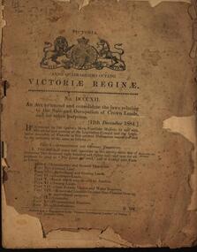
Booklet, An Act to amend and consolidate the laws relating to the Sale and Occupation of Crown Lands and for other purposes, 1884
... Sale and Occupation of Crown Lands and for other purposes, 1884...occupation of crown lands... and Occupation of Crown Lands and for other purposes, 1884 Brown soft ...Brown soft covered book of 48 pages. queen victoria, laws, victoria, sale of crown land, occupation of crown lands, selection, land act 1884 -
Federation University Historical Collection
Document, Crown Lands Act, 1862
... Crown Lands Act, 1862...Blue foolscap printed Government document on the Crown... Document Crown Lands Act, 1862 Blue foolscap printed Government ...Blue foolscap printed Government document on the Crown Lands Act. land, land sales, crown land, ararat, petition -
Whitehorse Historical Society Inc.
Document, Department of Crown Lands and Survey, 1983
... Department of Crown Lands and Survey... of Crown Lands and Survey. Compiled by P. Cabena, Aug 1983... Mitcham melbourne Document Document Department of Crown Lands ...Research guide of historical resources of the Department of Crown Lands and Survey. Compiled by P. Cabena, Aug 1983Research guide of historical resources of the Department of Crown Lands and Survey. Compiled by P. Cabena, Aug 1983Research guide of historical resources of the Department of Crown Lands and Survey. Compiled by P. Cabena, Aug 1983crown land, land surveys, victorian government -
 St Kilda Historical Society
Photograph - Photo map, Department of Crown Lands and Survey (1857-1983), 22/01/1970
... of Crown Lands and Survey (1857-1983). For correlation...Vic 2358 Department of Crown Lands and Survey Victoria,.©...Department of Crown Lands and Survey (1857-1983)... and white aerial photograph Vic 2358 Department of Crown Lands ...One of a series of photo-maps produced for the Department of Crown Lands and Survey (1857-1983). For correlation with a current map, and access to other historical photo maps of Victoria, see the Historic Photo-Maps Index published by the Department of Environment, Land, Water and Planning at https://services.land.vic.gov.au/DELWPmaps/historical-photomaps/Black and white aerial photographVic 2358 Department of Crown Lands and Survey Victoria,.© Melbourne 1970 Project Run 41E 22.1.70 5,100 ASL 62caulfield, caulfield north, st kilda east, armadale, 1970 -
 St Kilda Historical Society
Photograph - Photo map, Department of Crown Lands and Survey (1857-1983), 22/01/1970
... of Crown Lands and Survey (1857-1983). For correlation...Vic 2358 Department of Crown Lands and Survey Victoria,.©...Department of Crown Lands and Survey (1857-1983)... and white aerial photograph Vic 2358 Department of Crown Lands ...One of a series of photo-maps produced for the Department of Crown Lands and Survey (1857-1983). For correlation with a current map, and access to other historical photo maps of Victoria, see the Historic Photo-Maps Index published by the Department of Environment, Land, Water and Planning at https://services.land.vic.gov.au/DELWPmaps/historical-photomaps/Black and white aerial photographVic 2358 Department of Crown Lands and Survey Victoria,.© Melbourne 1970 Project Run 42E 22.1.70 5,100 ASL 77st kilda, st kilda east, st kilda marina, elwood, elwood canal, elsternwick park, point ormond, balaclava, mc moran reserve, ripponlea, st kilda botanical gardens, peanut farm, 1970 -
 St Kilda Historical Society
Photograph - Photo map, Department of Crown Lands and Survey, 22/01/1970
... of Crown Lands and Survey (1857-1983). For correlation...Vic 2358 Department of Crown Lands and Survey Victoria,.©...Department of Crown Lands and Survey ... and white aerial photograph Vic 2358 Department of Crown Lands ...One of a series of photo-maps produced for the Department of Crown Lands and Survey (1857-1983). For correlation with a current map, and access to other historical photo maps of Victoria, see the Historic Photo-Maps Index published by the Department of Environment, Land, Water and Planning at https://services.land.vic.gov.au/DELWPmaps/historical-photomaps/Black and white aerial photographVic 2358 Department of Crown Lands and Survey Victoria,.© Melbourne 1970 Project Run 43E 22.1.70 5,100 ASL 208elwood, elwood beach, point ormond, elwood park, elwood canal, mc moran reserve, 1970 -
 St Kilda Historical Society
Photograph - Photo map, Department of Crown Lands and Survey, 22/01/1970
... of Crown Lands and Survey (1857-1983). For correlation...Vic 2358 Department of Crown Lands and Survey Victoria,.©...Department of Crown Lands and Survey ... and white aerial photograph Vic 2358 Department of Crown Lands ...One of a series of photo-maps produced for the Department of Crown Lands and Survey (1857-1983). For correlation with a current map, and access to other historical photo maps of Victoria, see the Historic Photo-Maps Index published by the Department of Environment, Land, Water and Planning at https://services.land.vic.gov.au/DELWPmaps/historical-photomaps/Black and white aerial photographVic 2358 Department of Crown Lands and Survey Victoria,.© Melbourne 1970 Project Run 42E 22.1.70 5,100 ASL 75st kilda, st kilda beach, st kilda marina, point ormond, st kilda pier, 1970 -
 St Kilda Historical Society
Photograph - Photo map, Department of Crown Lands and Survey, 22/01/1970
... of Crown Lands and Survey (1857-1983). For correlation...Vic 2358 Department of Crown Lands and Survey Victoria,.©...Department of Crown Lands and Survey ... and white aerial photograph Vic 2358 Department of Crown Lands ...One of a series of photo-maps produced for the Department of Crown Lands and Survey (1857-1983). For correlation with a current map, and access to other historical photo maps of Victoria, see the Historic Photo-Maps Index published by the Department of Environment, Land, Water and Planning at https://services.land.vic.gov.au/DELWPmaps/historical-photomaps/Black and white aerial photographVic 2358 Department of Crown Lands and Survey Victoria,.© Melbourne 1970 Project Run 41E 22.1.70 5,100 ASL 64st kilda, st kilda cemetery, balaclava, st kilda east, windsor, caulfield north, alma park, 1970 -
 St Kilda Historical Society
Photograph - Photo map, Department of Crown Lands and Survey, 08/01/1970
... of Crown Lands and Survey (1857-1983). For correlation...Vic 2345 Department of Crown Lands and Survey Victoria,.©...Department of Crown Lands and Survey ... and white arial photograph Vic 2345 Department of Crown Lands ...One of a series of photo-maps produced for the Department of Crown Lands and Survey (1857-1983). For correlation with a current map, and access to other historical photo maps of Victoria, see the Historic Photo-Maps Index published by the Department of Environment, Land, Water and Planning at https://services.land.vic.gov.au/DELWPmaps/historical-photomaps/Black and white arial photographVic 2345 Department of Crown Lands and Survey Victoria,.© Melbourne 1970 Project Run 40 8.1.70 5,100 ASL 77albert park, fawkner park, south yarra, middle park, prahran, windsor, st kilda, st kilda west, 1970 -
 St Kilda Historical Society
Photograph - Photo map, 22/01/1970
... of Crown Lands and Survey (1857-1983). For correlation...Vic 2358 Department of Crown Lands and Survey Victoria,.©...Department of Crown Lands and Survey ... and white aerial photograph Vic 2358 Department of Crown Lands ...One of a series of photo-maps produced for the Department of Crown Lands and Survey (1857-1983). For correlation with a current map, and access to other historical photo maps of Victoria, see the Historic Photo-Maps Index published by the Department of Environment, Land, Water and Planning at https://services.land.vic.gov.au/DELWPmaps/historical-photomaps/Black and white aerial photographVic 2358 Department of Crown Lands and Survey Victoria,.© Melbourne 1970 Project Run 43E 22.1.70 5,100 ASL 206elwood, elsternwick, elsternwick park, 1970 -
 St Kilda Historical Society
Photograph - Photo map, Department of Crown Lands and Survey, 22/01/1970
... of Crown Lands and Survey (1857-1983). For correlation...CONTROLLED Vic 2358 Department of Crown Lands and Survey...Department of Crown Lands and Survey ... for the Department of Crown Lands and Survey (1857-1983). For correlation ...One of a series of photo-maps produced for the Department of Crown Lands and Survey (1857-1983). For correlation with a current map, and access to other historical photo maps of Victoria, see the Historic Photo-Maps Index published by the Department of Environment, Land, Water and Planning at https://services.land.vic.gov.au/DELWPmaps/historical-photomaps/Black and white aerial photographCONTROLLED Vic 2358 Department of Crown Lands and Survey Victoria,.© Melbourne 1970 Project Run 41E 22.1.70 5,100 ASL 66st kilda, albert park, st kilda west, catani gardens, st kilda botanical gardens, st kilda pier, st kilda beach, 1970 -
 Federation University Historical Collection
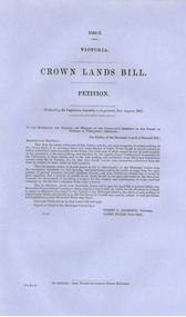
Document, Victorian Crown Lands Bill Petition, 1856-7, 1857
... Victorian Crown Lands Bill Petition, 1856-7...Blue Foolscap printed document relating to a Crown Lands... Document Victorian Crown Lands Bill Petition, 1856-7 Blue Foolscap ...Blue Foolscap printed document relating to a Crown Lands Bill Petition ordered by the Legislative Assembly to be printed on 21 August 1857.crown land, petition, emerald hill, robert anderson, james eville -
 Federation University Historical Collection
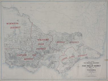
Plan, Map Showing the Pastoral Holdings of the Port Phillip District 1835-1851 Now Victoria, 1932
... crown lands...Crown Lands Department... squatting victoria land crown lands a.s. kenyon alfred stephen ...Another name for Pastoral Holdings is squatting runs. Information on Alfred Stephen Kenyon of the Historical Society of Victoria can be found at http://adb.anu.edu.au/biography/kenyon-alfred-stephen-6936/text12035 Map of Victoria showing the boundaries of the Port Phillip District (Victoria) pastoral boundaries. pastoral holdings, squatters, squatting, victoria, land, crown lands, a.s. kenyon, alfred stephen kenyon -
 Orbost & District Historical Society
plans, 1966?
... plans-survey Snowy-River-Flats Department-Crown-Lands...Department of Crown Lands & Survey...-Flats Department-Crown-Lands-Victoria Department of Crown Lands ...These survey plans are a useful research tool.A flat green fabric folder with a white label with "SNOWY RIVER FLATS" hand-written in black. It contains plans.plans-survey snowy-river-flats department-crown-lands-victoria -
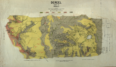 Federation University Historical Collection
Map, Dereel, County of Grenville, 1890
... crown lands department...Crown Lands Department... krause crown lands department plan Ferdinand M. Krause Crown ...Dereel is in western Victoria.Geological map of Dereel in the County of Grenville featuing six colours (predominantly grey and yellow). WGS 84 Centroid Lat: 37 degrees 48 feet 50 inches S Long:143 degrees 42 feet 10 inches S N-S: 6.4 km E-W: 15.2 km dereel, ferdinand krause, crown lands department, plan -
Phillip Island and District Historical Society Inc.
Book, MORGAN, Marjorie, Crown lands pre-emptive right applications : Victoria 1850-1854, 1987
... Crown lands pre-emptive right applications : Victoria 1850...'. Facsim. reprint. First published as: Valuation of Crown Lands...-island-and-the-bass-coast Book Crown lands pre-emptive right ...Stamped 'Phillip Island & District Historical Society'. Facsim. reprint. First published as: Valuation of Crown Lands under Pre-emptive Right. Melbourne : 1855.land settlement, victoria, history, land subdivision -
Ringwood and District Historical Society
Document - Land Title, John Quinlan et al, Land title (Ringwood) and correspondence between George Pratt of Nunawading and the Commissioner of Crown Lands 1869-1877, 1869
... Pratt of Nunawading and the Commissioner of Crown Lands 1869... and the Commissioner of Crown Lands and Survey dated 19th(?) August 1869... and the Commissioner of Crown Lands and Survey dated 19th(?) August 1869 ...Land title and correspondence between George Pratt and the Commissioner of Crown Lands and Survey dated 19th(?) August 1869. Numbered 16678 (1M) plus 20 pages marked 42M-61M +Additional Keywords: Commissioner of Land and Survey / Longmare, Mr. / Quinlan, John -
Stawell Historical Society Inc
Map, Department of Crown Lands and Survey Victoria, Allotments in the Township of Banyana. Parish of Burrum Burrum. 1946 / 1971, 1971
... at the Department of Crown Lands and Survey Victoria 1971....Department of Crown Lands and Survey Victoria... Junction Survey Department of Crown Lands and Survey Victoria ...Richardson River. Avon River JunctionPaper Map of County of BorungReprint of the 1946 edition. Drawn and reproduced at the Department of Crown Lands and Survey Victoria 1971.survey -
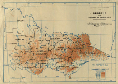 Federation University Historical Collection
Map, Victoria: Regions for Planning and Development, 1944
... Crown Lands and Survey...Crown Lands and Survey... Lands and Survey State Regional Boundaries Committee Crown Lands ...This map was produced for the State Regional Boundaries Committee Two colour map of Victoria showing the regions for planning and development. The regions are Central Highlands, Mallee, Wimmera, Glenelg, Corangamite, Barwon, Loddon, Goulburn, Upper Goulburn, Upper Murray, East Gippsland, West Gippsland, Port Phillip.central highlands, mallee, wimmera, glenelg, corangamite, barwon, loddon, goulburn, upper goulburn, upper murray, east gippsland, west gippsland, port phillip, victoria, m4486